Hi from W9NOP,
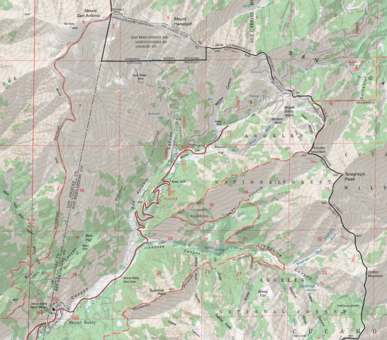
I'm trying to connect to AREDN from my rustic cabin in a steep canyon on Mt. Baldy with a wood burning store and an outhouse. According to iPhone Compass:
34 degrees 15' and 24" N.
117 degrees 38' and 18" W
5,500 feet elevation.
I've looked at an AREDN map and it appears I'll be shooting down the Mt. Baldy canyon into Los Angeles County; not San Bernardino or Riverside County.
I'm understanding that I should use 5.8 GHz and a dish with a range of about 30 miles.
I'm looking for a node I can communicate with. Then that node will inform me of what equipment to purchase and setup. I know some people in Orange County on AREDN that will help me load the software and set up the equipment. I've been told that then I'll need to mount the dish and perform an azimuth and elevation test to determine the optimal physical setting and then lock down the dish position. Finally, I'll need to connect and establish the network settings.
I contacted one node in Pasadena and he told me he tunnels and cannot help me.
Thanks,
Rodney Schaerer
You are here
Newbie looking to connect to a mode from Mt. Baldy.
Wed, 10/05/2022 - 00:29
#1
Newbie looking to connect to a mode from Mt. Baldy.
Theme by Danetsoft and Danang Probo Sayekti inspired by Maksimer

Rodney, getting a line-of-sight microwave radio signal out of that narrow canyon is going to be very challenging. If you have clear line of sight to one of the surrounding mountain peaks, then a relay node on a nearby peak may be the best way to get from the bottom of the canyon out to the nodes in the LA basin to your south. If you have some way to get an Internet connection from your cabin then you could possibly connect to the SoCal mesh by tunneling from your node to one of the nodes in the LA basin until you can establish a mountaintop relay node.
