Is there a way to heat map aredn coverage? So far I have it been working with indoor hap aclite but was thinking about tossing an outdoor node to see what actual coverage I could get. I have tried online rf simulators but it is just a simulation, real world performance would be more factual.
Theme by Danetsoft and Danang Probo Sayekti inspired by Maksimer
Samples here (scroll down below 1st 7 images):
http://miamivalleymesh.com/images/Profiles/
Others here have mentioned 'Radio Mobile', 'Google Earth, and (IIRC) Ubiquiti has a free a mapping tool.
Chuck
I have some profilers and have used both heywhatsthat and link.ui but I was thinking more of a wifi heat map. something like https://www.ekahau.com/wp-content/uploads/2020/05/Capacity-Area-Planning... or https://www.acrylicwifi.com/wp-content/uploads/2015/05/How-to-create-a-h... but instead of using an indoor map using a map of the surrounding area. Ideally one could walk/drive around and map the signal strength. I have done similar with indoor using a cellphone but everything I been researching appears to only use commercial wifi bands. I wasn't sure if someone tried this before or not but thought installing a node and walking/driving around to get a heatmap would provide some information that online profilers may not recognize?
Two sides to the coin.
1) computer coverage prediction using a tool like Radio Mobile.
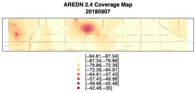
2) field coverage measurement and plotting.
This example used a "wardriving" approach and then the R language to "Krige" the data on openstreetmap.
This may actually be better as it would map more of a worst case scenario, however does anyone know (even if a ball park guess) how much of an impact this would have on the measurements? I know there are a ton of variables and it is a very open ended question so I understand the level of what I am asking. I am just trying to evaluate if this information would even be of value or if it would be so squed it wouldn't even be worth it?
Basically if you were linking two nodes together on a commercial frequency over a distance how far or how far would be a realistic distance be achievable having public accesspoints competting on the same frequencies?
Hope this helps.